What on Earth?
What on Earth? is a tool for exploring quaternions, geometry, and satellite perspectives—all from the comfort of your browser. It provides an interactive 3D environemtn to perform complex geometric calculations, visualize scenes from a satellite’s viewpoint, and optimize quaternions under various constraints.
Key Features
- Geometric Calculations: Compute angles, distances, and other geometrical properties.
- Satellite Perspectives: Simulate and analyze views from a satellite’s camera, complete with orientation and field of view adjustments.
- Quaternion Optimization: Determine the best quaternion given constraints such as:
- Specific camera orientations.
- Alignment of secondary vectors or targets.
- User-Driven Scripting: Write and execute scripts directly in the app’s built-in editor using a custom API or DSL, enabling:
- Adding new points or objects to the scene.
- Performing calculations on-the-fly.
- Automating workflows for repeated tasks.
- Time-based simulations with adjustable simulation time
- ... much more coming soon.
Getting Started
User Interface
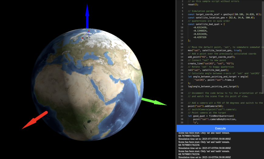
The application interface is divided into the following areas:
Simulation View (Left): The main 3D visualization area showing the Earth globe, satellite points, and other geometric elements. You can rotate and zoom the view using your mouse.
Code Editor (Right): A full-featured code editor where you can write and edit your script using the application's DSL. The editor includes syntax highlighting and auto-completion features.
Execute Button: Located below the editor, this button runs your current script and update the simulation accordingly.
Settings Tabs: On the left edge of the editor panel, vertical tabs provide access to additional features:
- Editor: The main coding interface
- Settings: Configuration options for the simulation, including time controls and visualization settings
Example workflow
Let's walk through a practical example of using What on Earth? to debug quaternion orientations. This workflow will show you how to:
- Position a satellite
- Create reference points
- Analyze orientations
- Calculate angles between vectors
Here's a complete example you can copy/paste into the integrated editor:
// Move the default point, `sat`, near Helsinki
mov("sat", [62.0, 34.0, 500.0], true);

// Kuva Space HQ
let ksCoords = geo2xyz([60.186, 24.828, 0]);
addPoint("KS", ksCoords);

// Create a line between satellite and point
createLine("sat2KS", "sat", "KS");

// Apply a test quaternion rotation
rot("sat", [-0.6313439, -0.1346824, -0.6313439, -0.4297329]);

// Calculate angle between satellite's z-axis and the line
angle("sat2KS", point("sat").frame.z);
Full details on how this example works can be found the debugging quaternions workflow example. For more examples and detailed workflows, check out our workflow guides.
DSL Documentation
Dive into the scripting capabilities provided by the app’s DSL. Read the documentation.